


Be Your Own Forecaster: Chile Volcano Skiing
Aidan Goldie-Ahumada used his CalTopo Adventure Grant to return to his home country of Chile to attempt several ski mountaineering missions. With limited information available, Aidan and his team were challenged to build their own forecasts across three distinct snowpacks. He left with a new perspective, and some of the best ski descents of his life. Below is his trip report- enjoy!
In the austral winter of 2022, I was afforded the opportunity to take a trip to Chile with the generous support of the CalTopo Adventure Grant. The goal of the trip was to ski remote volcanoes in the Andes range of South America. Our month-long trip gave us a little bit of everything, from extended ski tours in challenging conditions to some of the best ski descents of our lives. This trip report will highlight a few of the locations we visited and how we approached the process of trip planning for a variety of objectives.
This trip was particularly meaningful for me due to my Chilean heritage. I was born in Chile in a coastal town surrounded by the Atacama desert. After a few years, our family emigrated from Chile and ultimately settled in North America. Chile, for many years to come, was a country where I would visit to see family around the holidays, eat good seafood, and enjoy time on the beach. More than anything, this trip granted me the opportunity to see my home country in a new way. Through the lens of ski mountaineering, I was pushed into small mountain towns and remote locations that I never had the chance to experience otherwise. It is a privileged opportunity to feel like a tourist in your home country and witness the regionality of a country as diverse as Chile.
At the present moment, I live in the Roaring Fork Valley near Aspen, Colorado. In Colorado, we are very lucky to have an infrastructure to both access high-elevation mountains, and dedicated weather and avalanche forecasting. Every winter, I get into a morning routine that starts with the Colorado Avalanche Information Center bulletin quickly followed by a trip to CalTopo for the rest of my trip planning. This is a luxury that I, and other Colorado-based backcountry skiers, have because a lot of the burden of data collection falls onto other avalanche professionals. We have a talented group of avalanche forecasters around the state, and the American west, that post their observations online for others to see. These observations, along with user-submitted observations, are compiled in the form of an avalanche forecast that can highlight the critical avalanche problems that one can anticipate on a given day. This is especially important in Colorado as we will hold a tricky avalanche problem called a “persistent weak layer” throughout most of the winter. It takes many observations over a large spatial range to identify the nature of that avalanche problem so having that forecasting infrastructure is important for backcountry skiers in Colorado to recreate within appropriate margins of risk.
When you access mountains in remote parts of the world, that privileged infrastructure ceases to exist. In essence, you need to be your own forecaster. This includes tracking the season’s historical snowfall to predict the structure of a region’s snowpack, tracking weather patterns and conditions, and making field-level assessments to verify modeled forecasts. My professional-level avalanche certifications have given me a foundation to do this individualized forecasting but I have found CalTopo to be a particularly useful tool that compiles a lot of that forecasting data in one location to get a clear picture of both the snowpack and the day-to-day conditions that can influence the avalanche problems.
In this trip report, I will highlight three distinct regions of Chile that we visited and the three distinct snowpacks that we encountered. Each type of snowpack takes a different approach to trip planning and terrain selection. All of which necessitated the use of remote weather forecasting and high-quality mapping software such as CalTopo.
Los Lagos: Maritime Snowpack
Chile’s Lake District is defined by the many lakes and Andean foothills that lead into the Pacific Ocean. From these foothills emerge a chain of volcanoes birthed from a major tectonic subduction zone that created the Andean Mountain Range.
Our trip started in the heart of Chile’s lake district and the gateway to Patagonia, Puerto Montt. Settled in an ocean inlet with a topography that allowed the construction of ports that can accommodate large cargo ships, Puerto Montt is a bustling city with dramatic volcanoes on the horizon. With moisture-laden air quickly rising from the ocean and onto the peaks only a short distance from the coast, we found a heavy maritime snowpack. A maritime snowpack is characterized by the moist ocean air that will drop deep and heavy snow as it makes its way up and over the Andes. Throughout this district, we would see a distinct snow line as rain transitions to sleet and then to heavy wet snow as the moist air quickly rises in elevation and begins to drop that moisture as the air pressure decreases.

In terms of avalanche concerns, we would expect to see a stronger deep snowpack structure and avalanche concerns arising from newer storm snow.
The highlight of this leg of the trip was on the prominent mountain seen from Puerto Montt, the Osorno Volcano. When we first arrived, we took our rental around the large Lago Llanquihue with black-sanded beaches and marveled at the fresh coat of snow that had fallen only a few hours before. We drove on a road that snakes through a lush rainforest with a thick understory and dark volcanic soil. As we wind up the side of the mountain we quickly start seeing this rainforest transition into a snowy landscape as we reach the critical elevation where colder temperatures can support snow crystal formation.
The small patches of snow on the side of the road quickly turned to snow banks and then suddenly the road was impassable. We would later learn from a local that this snowstorm dropped snow at some of the lowest elevations in about 10 years effectively closing the road further down than it had closed in recent memory.
At the road closure, we were a couple of thousand feet below and a handful of miles away from our intended stay for the night, the Refugio Teski. We packed up our bags for a couple of nights and toured up to the Refugio which also serves as the base of the small Osorno ski lifts. We found the Refugio surrounded by drifted snow and a small staff waiting inside. The staff at the Refugio Teski was very accommodating as we dried our gear and got our packs ready for a long outing the following day.

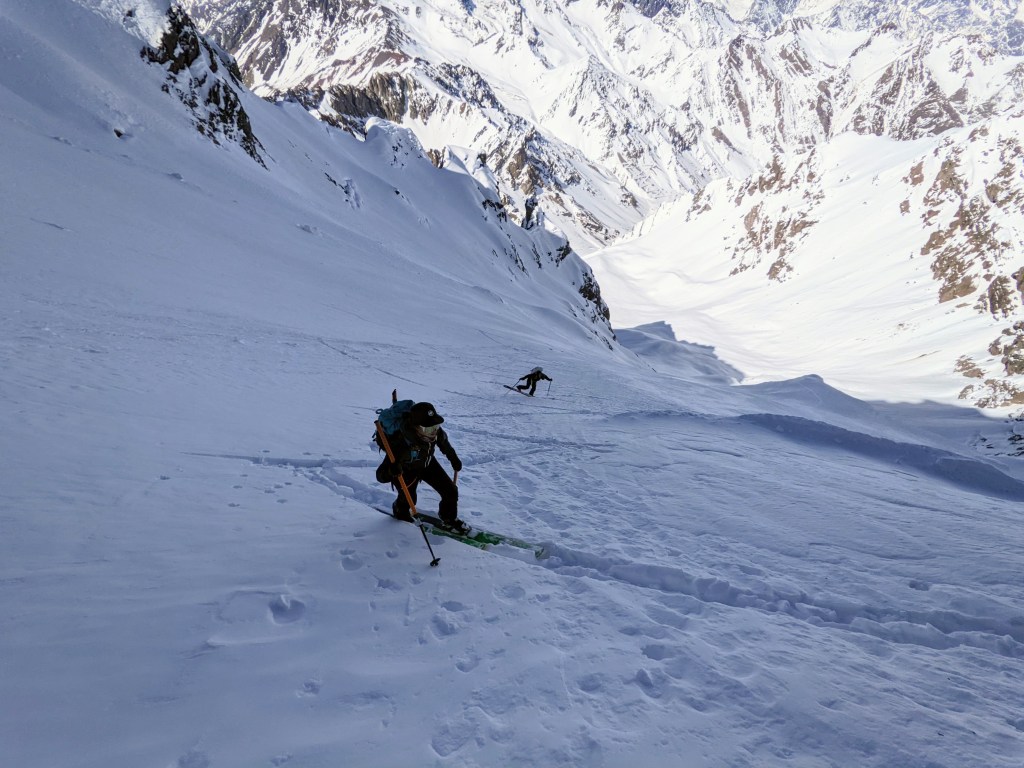
From the Refugio, we climbed another 5,000 feet to the summit of Osorno early the next morning. The previous evening we watched strong winds take snow up and over the volcano as a prominent lenticular cloud formed over the summit. We would need to ski the windward side of the volcano and hope that the wind had not carried too much of the fresh snow over to the other side, otherwise a very firm and icy climb and ski descent awaited us.
As we started touring up the western flank of the volcano, we quickly observed the difference that a small aspect change can make in the snow quality. On the southern side of the mountain, the aspect that took the brunt of the gale-force winds, we found large swaths of rime ice-crusted ski-lift towers and ridge lines. Following the contour of the mountain towards the west, the snow softened up and revealed a nicely preserved, albeit slightly wind-buffed, western aspect of the mountain that would make for an excellent ski descent. We made quick work of the climb, skinning through the soft and supportable snow until the slope became too steep to skin the closer we got to the summit crater. On the summit, we found a clear and calm moment to eat lunch and enjoy the rarity of a calm Patagonian summit.
Our group transitioned our skis for the downhill and enjoyed a 6,000-foot ski descent along the western flank of Osorno with perfect and creamy powder turns along the way.

Araucanía: Intermountain Snowpack
With the great success of finding a long ski descent in great snow conditions we drove north to chase a storm in the Araucania region of Chile. Further away from the moist maritime air, the Araucania Mountains largely hold an intermountain snowpack, one that is characterized by greater temperature fluctuations than those found near the ocean-buffered maritime regions and therefore more variability in an intermountain’s snowpack structure. This variability is combated by a deeper overall snowpack that is needed to ski steeper objectives. We set forth to the mountain town of Pucon to catch a significant low-pressure system that was looking likely to deliver a monster snowstorm.
We arrived in Pucon late at night as the first snowflakes started falling and dropped 22 inches on the Araucania mountains overnight. With powder on our minds, we woke up early the next morning to pay a visit to the towering monolithic volcano above the town of Pucon, Villarica. As we started driving up the access road towards Villarica, we started seeing cars sliding on the steep road, a sign that we needed to stop and put on our chains. After wrestling the chains onto our tires we were only able to drive a few hundred more feet before a Chilean Police car made the call to stop traffic from going any further.
This is where we realized that a large snowstorm does not have the same effect as our Colorado Mountains. Here there isn’t the government infrastructure to plow the roads and make mountain roads passable for everyday citizens. This kind of investment is only made on select high mountain passes that truckers use to ship goods between Chile and Argentina. In the small town of Pucon, once the snow falls and makes a road impassable, that road remains impassable until the snow melts again. From this point we realized that our strategy of following storms would not be as effective as we imagined.
This poses a problem because a large snowstorm that would indicate a delicious powder day at home, only posed a great hurdle in accessing the higher mountains. At the road closure, we found an additional 5 miles and 2000 feet of elevation gain to ski on the Villarica Volcano. With that in mind, we decided to regroup and rest for a summit attempt the following morning.
Villarica is one of the few volcanoes in the Andes with an active summit crater. As a small child, I remember seeing the red glow of lava spurting out of the summit volcano during a particularly eruptive event. When the volcano is not spurting lava from the summit, one can still see a steady stream of vapor emerging from the summit crater. This vapor is a combination of carbon dioxide and sulfur dioxide gas. Sulfur dioxide proves to be a nasty gas to interact with as it will come in contact with the water vapor in your lungs and create sulfuric acid and quickly tear away at your lung tissue if inhaled.

To make a summit bid, one not only needs a clear weather window but also a constant prevailing wind. It could prove dangerous if the wind, and the direction of the sulfur dioxide gas, shifted unexpectedly while we were on or near the summit.
With the threat of lung damage on the mind, we dug into the wind forecast for the area to determine the prevailing wind direction and strength and whether those variables would change during our summit attempt. CalTopo has a wind plot layer that displays current and forecasted winds and I’ve found it very useful in Colorado, particularly for forecasting wind slab avalanche problems in the event of a wind event following a snow storm. However because it pulls data from the National Weather Service, this feature is not available outside the continental US and thus was not a tool at our disposal for this particular objective. To learn more about wind plot as well as other weather forecasting layers, check out the Forecast Overlays section in the CalTopo user guide.

A PDF of Villarica generated from CalTopo with MapBuilder Topo and slope angle shading layers shown.
After a long morning skinning up the remainder of the access road and the southern flank of the volcano, we donned crampons and ice axes with the wind on our backs for the last 1000 feet to the summit of Villarica. With more wind effect and a ski descent on the windward side of the mountain, we did not get that dreamlike powdered ski descent that we got on Osorno but instead scraped down the icy and steep Villarica head wall before picking up some intermittent, chalky turns further down the flanks of the mountain.

Cajon Del Maipo: Continental Snowpack
After our time in the Araucania region, our group traveled north to visit one of the premiere ski-mountaineering destinations in Chile, El Cajon Del Maipo. We traded the comfort of skiing volcanoes for the thrill of making tight turns on long and steep couloirs.
Cajon Del Maipo is a mountain valley in the high-elevation Andes Mountains southwest of Santiago, Chile. Sitting on the border between Chile and Argentina, these mountains rise above 13,000 feet with the towering Aconcagua peak to the north. Here we found some of the most interesting and complex terrain of the trip that necessitated the use of a diverse skill set to both climb up and safely ski down.

This part of the Andes has less moisture than its maritime counterpart and some brutally cold high-elevation night-time temperatures. This yields a shallow snowpack that is particularly vulnerable to faceting. Faceting is a process of snow metamorphism that we are all too familiar with here in Colorado. In essence, faceting takes away the cohesive properties of snow and yields a snow crystal deep in the snowpack that is easy for the snowpack to slide on- think of a cutting board resting on the bed of marbles. Continental snowpacks are a staple of regions with comparatively shallow snowpacks and cold nighttime temperatures and pose unique avalanche problems.
One way to combat the persistent weak layer that readily forms in this type of snowpack is to focus your attention on solar aspects that will sinter the snowpack and potentially melt away some of those faceted snow crystals. While we would seek out south-facing aspects in our home Colorado mountains, in the Southern Hemisphere we would seek out north-facing aspects. CalTopo’s sun exposure overlay proved useful in our search for solar aspects, allowing us to not only find solar-radiated slopes but also allowed us to get an idea of the way that a region’s topography affected snow as well. To learn more about using this layer, visit the Sun Exposure overlay section of the CalTopo user guide.
This tool helped us to predict that the long and steep apron of the line we were planning to ski had experienced a significant amount of solar radiation, and could be consolidated to a point where we could safely skin up that vulnerable portion of the line in the cold early morning hours. The tight couloir above is sheltered from the day-to-day sunlight and would require small-scale decision making as we navigated. The ideal conditions would be to ski chalky and supportable snow in the couloir and then catch sun-softened snow on the apron.
As we made our way beyond the apron and climbed into the couloir above us, the scale of the line quickly became apparent. This peak holds three parallel couloirs that each are roughly 3,000 feet in length and would require a couple of hours of delicately placing our crampons on the firm snow. We navigate the couloir, alternating from side-to-side to find slightly softer snow while making careful assessments of the snowpack. We step wide of panels of wind-drifted snow considering the snow slab that could have developed.
Finally, we rest at the top of the line where the continuous snow ends and gives way to an overhanging rocky ledge above. We carefully remove our avalanche shovels from our packs and dig benches in the 50-degree slope to step into our bindings. We begin the careful dance of meticulously orchestrated jump turns, edge to edge, rotating our hips with our eyes firmly locked down at the 3000 feet of edgeable but firm snow below us.
Closing Thoughts:
This project offered significance in two different areas in my life. This project represents an elegant progression in my career as a ski mountaineer, as well as a rare opportunity to not only return to my birth country but to rekindle intimate cultural connections through travel and exploration.
From a ski-mountaineering perspective, this project is an opportunity to climb and ski in a region that is largely ignored by western climbers. As a ski mountaineer, I needed to rely on my ability to draw on a wide library of refined climbing systems to safely access this terrain. This trip challenged my experience as an avalanche professional to forecast conditions remotely and with limited remote sensing data. This expedition represented the union of a lifetime of mountain skills and a key test for myself in my climbing progression.
Most importantly, this project represents a reunion with my cultural roots. As an immigrant to the United States, my parents and I left Chile with tremendous sacrifice knowing that their children’s outcomes can improve with the abundance of resources an American has access to. I am thankful for the life I have been able to live in the United States and the opportunities to grow as an ecologist, educator, and ski mountaineer. As any immigrant will find, the opportunities opened up can’t fill the hole left by the trauma of leaving family and culture behind on a different continent.
I was born in the Altiplano of Chile, not the mystical Patagonia that is so often romanticized by western media, but the vast, high-elevation, salt-encrusted earth at the northern end of Chile. There is a strong foundation of culture in Chile, one that intimately ties people and the Earth.

This a reminder that we are not a species removed from the earth, but part of the biosphere. Throughout this trip, as we made our way from snowpack to snowpack, from ecosystem to ecosystem, I saw a culture that was fundamentally Chilean, but distinct in the way that different communities were tied to their natural surroundings. A fundamental contrast from the life I have built in the United States. Chilean communities shape their lives around their home ecosystem rather than trying to change the natural space around them to fit their lives.
As Chile grapples with the lasting effects of a military dictatorship and modern neoliberalism, communities tucked away in remote and ecologically diverse regions of the country best exemplify what it means to be Chilean. A community-centered culture that shows love through food, family time, and an intimate connection to the environment they belong to. I am grateful for the many people that made this trip possible. Thank you to the CalTopo Adventure Grant for supporting my trip and others in their exploration of under-explored parts of the globe.
Aidan used CalTopo’s international base layers to plan his ski mountaineering objectives. CalTopo offers worldwide coverage for the MapBuilder Topo, MapBuilder Hybrid and Global Imagery base layers as well as more limited international coverage for Scanned Topos. These layers can be downloaded for offline use on your mobile device with a mobile, pro or desktop subscription. Visit our Individual Accounts page to learn more about the features and pricing of CalTopo’s individual subscriptions.


Hi Aidan – I feel very similar to you – my entire family is Chilean but we moved to the US when I was young. I got into skiing in my early 20’s and live in Golden, CO, and my passion for backcountry skiing has taken over the last few years. My memories of Chile have always been visiting a country as a tourist but to see family, much like how you describe it. My most recent trip to Chile in October made me wish I brought my skis, as my family lives in Los Lagos, and the Puntiagudo, Osorno, and Villarica volcanos all looked prime for skiing conditions. My dream is to bring skis down there at some point and have a trip similar to yours. This was an awesome read. Thank you very much for sharing!