In May 2022, CalTopo Adventure Grant recipient Sean Marble attempt to climb the north ridge of Mount Hayes and then packraft out the Little Delta River. Over the course of the trip, Sean and his partners faced a myriad of challenge: hidden crevasses, precarious tent platforms, exposed climbing, challenging weather, endless postholing, and rivers bordered by towering ice wall. All in all, a proper Alaskan adventure!
If you’d like to learn more about Sean’s trip, make sure to check out his full trip report here.
https://blog.caltopo.com/wp-content/uploads/2019/10/caltopoLogo_menu1.png00Meghanhttps://blog.caltopo.com/wp-content/uploads/2019/10/caltopoLogo_menu1.pngMeghan2023-02-16 12:55:032023-02-16 12:55:03Mt Hayes North Ridge (Full Video)
Aidan Goldie-Ahumada used his CalTopo Adventure Grant to return to his home country of Chile to attempt several ski mountaineering missions. With limited information available, Aidan and his team were challenged to build their own forecasts across three distinct snowpacks. He left with a new perspective, and some of the best ski descents of his life. Below is his trip report- enjoy!
In the austral winter of 2022, I was afforded the opportunity to take a trip to Chile with the generous support of the CalTopo Adventure Grant. The goal of the trip was to ski remote volcanoes in the Andes range of South America. Our month-long trip gave us a little bit of everything, from extended ski tours in challenging conditions to some of the best ski descents of our lives. This trip report will highlight a few of the locations we visited and how we approached the process of trip planning for a variety of objectives.
This trip was particularly meaningful for me due to my Chilean heritage. I was born in Chile in a coastal town surrounded by the Atacama desert. After a few years, our family emigrated from Chile and ultimately settled in North America. Chile, for many years to come, was a country where I would visit to see family around the holidays, eat good seafood, and enjoy time on the beach. More than anything, this trip granted me the opportunity to see my home country in a new way. Through the lens of ski mountaineering, I was pushed into small mountain towns and remote locations that I never had the chance to experience otherwise. It is a privileged opportunity to feel like a tourist in your home country and witness the regionality of a country as diverse as Chile.
At the present moment, I live in the Roaring Fork Valley near Aspen, Colorado. In Colorado, we are very lucky to have an infrastructure to both access high-elevation mountains, and dedicated weather and avalanche forecasting. Every winter, I get into a morning routine that starts with the Colorado Avalanche Information Center bulletin quickly followed by a trip to CalTopo for the rest of my trip planning. This is a luxury that I, and other Colorado-based backcountry skiers, have because a lot of the burden of data collection falls onto other avalanche professionals. We have a talented group of avalanche forecasters around the state, and the American west, that post their observations online for others to see. These observations, along with user-submitted observations, are compiled in the form of an avalanche forecast that can highlight the critical avalanche problems that one can anticipate on a given day. This is especially important in Colorado as we will hold a tricky avalanche problem called a “persistent weak layer” throughout most of the winter. It takes many observations over a large spatial range to identify the nature of that avalanche problem so having that forecasting infrastructure is important for backcountry skiers in Colorado to recreate within appropriate margins of risk.
When you access mountains in remote parts of the world, that privileged infrastructure ceases to exist. In essence, you need to be your own forecaster. This includes tracking the season’s historical snowfall to predict the structure of a region’s snowpack, tracking weather patterns and conditions, and making field-level assessments to verify modeled forecasts. My professional-level avalanche certifications have given me a foundation to do this individualized forecasting but I have found CalTopo to be a particularly useful tool that compiles a lot of that forecasting data in one location to get a clear picture of both the snowpack and the day-to-day conditions that can influence the avalanche problems.
In this trip report, I will highlight three distinct regions of Chile that we visited and the three distinct snowpacks that we encountered. Each type of snowpack takes a different approach to trip planning and terrain selection. All of which necessitated the use of remote weather forecasting and high-quality mapping software such as CalTopo.
Los Lagos: Maritime Snowpack
Chile’s Lake District is defined by the many lakes and Andean foothills that lead into the Pacific Ocean. From these foothills emerge a chain of volcanoes birthed from a major tectonic subduction zone that created the Andean Mountain Range.
Our trip started in the heart of Chile’s lake district and the gateway to Patagonia, Puerto Montt. Settled in an ocean inlet with a topography that allowed the construction of ports that can accommodate large cargo ships, Puerto Montt is a bustling city with dramatic volcanoes on the horizon. With moisture-laden air quickly rising from the ocean and onto the peaks only a short distance from the coast, we found a heavy maritime snowpack. A maritime snowpack is characterized by the moist ocean air that will drop deep and heavy snow as it makes its way up and over the Andes. Throughout this district, we would see a distinct snow line as rain transitions to sleet and then to heavy wet snow as the moist air quickly rises in elevation and begins to drop that moisture as the air pressure decreases.
In terms of avalanche concerns, we would expect to see a stronger deep snowpack structure and avalanche concerns arising from newer storm snow.
The highlight of this leg of the trip was on the prominent mountain seen from Puerto Montt, the Osorno Volcano. When we first arrived, we took our rental around the large Lago Llanquihue with black-sanded beaches and marveled at the fresh coat of snow that had fallen only a few hours before. We drove on a road that snakes through a lush rainforest with a thick understory and dark volcanic soil. As we wind up the side of the mountain we quickly start seeing this rainforest transition into a snowy landscape as we reach the critical elevation where colder temperatures can support snow crystal formation.
The small patches of snow on the side of the road quickly turned to snow banks and then suddenly the road was impassable. We would later learn from a local that this snowstorm dropped snow at some of the lowest elevations in about 10 years effectively closing the road further down than it had closed in recent memory.
At the road closure, we were a couple of thousand feet below and a handful of miles away from our intended stay for the night, the Refugio Teski. We packed up our bags for a couple of nights and toured up to the Refugio which also serves as the base of the small Osorno ski lifts. We found the Refugio surrounded by drifted snow and a small staff waiting inside. The staff at the Refugio Teski was very accommodating as we dried our gear and got our packs ready for a long outing the following day.
From the Refugio, we climbed another 5,000 feet to the summit of Osorno early the next morning. The previous evening we watched strong winds take snow up and over the volcano as a prominent lenticular cloud formed over the summit. We would need to ski the windward side of the volcano and hope that the wind had not carried too much of the fresh snow over to the other side, otherwise a very firm and icy climb and ski descent awaited us.
As we started touring up the western flank of the volcano, we quickly observed the difference that a small aspect change can make in the snow quality. On the southern side of the mountain, the aspect that took the brunt of the gale-force winds, we found large swaths of rime ice-crusted ski-lift towers and ridge lines. Following the contour of the mountain towards the west, the snow softened up and revealed a nicely preserved, albeit slightly wind-buffed, western aspect of the mountain that would make for an excellent ski descent. We made quick work of the climb, skinning through the soft and supportable snow until the slope became too steep to skin the closer we got to the summit crater. On the summit, we found a clear and calm moment to eat lunch and enjoy the rarity of a calm Patagonian summit.
Our group transitioned our skis for the downhill and enjoyed a 6,000-foot ski descent along the western flank of Osorno with perfect and creamy powder turns along the way.
Araucanía: Intermountain Snowpack
With the great success of finding a long ski descent in great snow conditions we drove north to chase a storm in the Araucania region of Chile. Further away from the moist maritime air, the Araucania Mountains largely hold an intermountain snowpack, one that is characterized by greater temperature fluctuations than those found near the ocean-buffered maritime regions and therefore more variability in an intermountain’s snowpack structure. This variability is combated by a deeper overall snowpack that is needed to ski steeper objectives. We set forth to the mountain town of Pucon to catch a significant low-pressure system that was looking likely to deliver a monster snowstorm.
We arrived in Pucon late at night as the first snowflakes started falling and dropped 22 inches on the Araucania mountains overnight. With powder on our minds, we woke up early the next morning to pay a visit to the towering monolithic volcano above the town of Pucon, Villarica. As we started driving up the access road towards Villarica, we started seeing cars sliding on the steep road, a sign that we needed to stop and put on our chains. After wrestling the chains onto our tires we were only able to drive a few hundred more feet before a Chilean Police car made the call to stop traffic from going any further.
This is where we realized that a large snowstorm does not have the same effect as our Colorado Mountains. Here there isn’t the government infrastructure to plow the roads and make mountain roads passable for everyday citizens. This kind of investment is only made on select high mountain passes that truckers use to ship goods between Chile and Argentina. In the small town of Pucon, once the snow falls and makes a road impassable, that road remains impassable until the snow melts again. From this point we realized that our strategy of following storms would not be as effective as we imagined.
This poses a problem because a large snowstorm that would indicate a delicious powder day at home, only posed a great hurdle in accessing the higher mountains. At the road closure, we found an additional 5 miles and 2000 feet of elevation gain to ski on the Villarica Volcano. With that in mind, we decided to regroup and rest for a summit attempt the following morning.
Villarica is one of the few volcanoes in the Andes with an active summit crater. As a small child, I remember seeing the red glow of lava spurting out of the summit volcano during a particularly eruptive event. When the volcano is not spurting lava from the summit, one can still see a steady stream of vapor emerging from the summit crater. This vapor is a combination of carbon dioxide and sulfur dioxide gas. Sulfur dioxide proves to be a nasty gas to interact with as it will come in contact with the water vapor in your lungs and create sulfuric acid and quickly tear away at your lung tissue if inhaled.
To make a summit bid, one not only needs a clear weather window but also a constant prevailing wind. It could prove dangerous if the wind, and the direction of the sulfur dioxide gas, shifted unexpectedly while we were on or near the summit.
With the threat of lung damage on the mind, we dug into the wind forecast for the area to determine the prevailing wind direction and strength and whether those variables would change during our summit attempt. CalTopo has a wind plot layer that displays current and forecasted winds and I’ve found it very useful in Colorado, particularly for forecasting wind slab avalanche problems in the event of a wind event following a snow storm. However because it pulls data from the National Weather Service, this feature is not available outside the continental US and thus was not a tool at our disposal for this particular objective. To learn more about wind plot as well as other weather forecasting layers, check out the Forecast Overlays section in the CalTopo user guide.
A PDF of Villarica generated from CalTopo with MapBuilder Topo and slope angle shading layers shown.
After a long morning skinning up the remainder of the access road and the southern flank of the volcano, we donned crampons and ice axes with the wind on our backs for the last 1000 feet to the summit of Villarica. With more wind effect and a ski descent on the windward side of the mountain, we did not get that dreamlike powdered ski descent that we got on Osorno but instead scraped down the icy and steep Villarica head wall before picking up some intermittent, chalky turns further down the flanks of the mountain.
Cajon Del Maipo: Continental Snowpack
After our time in the Araucania region, our group traveled north to visit one of the premiere ski-mountaineering destinations in Chile, El Cajon Del Maipo. We traded the comfort of skiing volcanoes for the thrill of making tight turns on long and steep couloirs.
Cajon Del Maipo is a mountain valley in the high-elevation Andes Mountains southwest of Santiago, Chile. Sitting on the border between Chile and Argentina, these mountains rise above 13,000 feet with the towering Aconcagua peak to the north. Here we found some of the most interesting and complex terrain of the trip that necessitated the use of a diverse skill set to both climb up and safely ski down.
This part of the Andes has less moisture than its maritime counterpart and some brutally cold high-elevation night-time temperatures. This yields a shallow snowpack that is particularly vulnerable to faceting. Faceting is a process of snow metamorphism that we are all too familiar with here in Colorado. In essence, faceting takes away the cohesive properties of snow and yields a snow crystal deep in the snowpack that is easy for the snowpack to slide on- think of a cutting board resting on the bed of marbles. Continental snowpacks are a staple of regions with comparatively shallow snowpacks and cold nighttime temperatures and pose unique avalanche problems.
One way to combat the persistent weak layer that readily forms in this type of snowpack is to focus your attention on solar aspects that will sinter the snowpack and potentially melt away some of those faceted snow crystals. While we would seek out south-facing aspects in our home Colorado mountains, in the Southern Hemisphere we would seek out north-facing aspects. CalTopo’s sun exposure overlay proved useful in our search for solar aspects, allowing us to not only find solar-radiated slopes but also allowed us to get an idea of the way that a region’s topography affected snow as well. To learn more about using this layer, visit the Sun Exposure overlay section of the CalTopo user guide.
This tool helped us to predict that the long and steep apron of the line we were planning to ski had experienced a significant amount of solar radiation, and could be consolidated to a point where we could safely skin up that vulnerable portion of the line in the cold early morning hours. The tight couloir above is sheltered from the day-to-day sunlight and would require small-scale decision making as we navigated. The ideal conditions would be to ski chalky and supportable snow in the couloir and then catch sun-softened snow on the apron.
As we made our way beyond the apron and climbed into the couloir above us, the scale of the line quickly became apparent. This peak holds three parallel couloirs that each are roughly 3,000 feet in length and would require a couple of hours of delicately placing our crampons on the firm snow. We navigate the couloir, alternating from side-to-side to find slightly softer snow while making careful assessments of the snowpack. We step wide of panels of wind-drifted snow considering the snow slab that could have developed.
Finally, we rest at the top of the line where the continuous snow ends and gives way to an overhanging rocky ledge above. We carefully remove our avalanche shovels from our packs and dig benches in the 50-degree slope to step into our bindings. We begin the careful dance of meticulously orchestrated jump turns, edge to edge, rotating our hips with our eyes firmly locked down at the 3000 feet of edgeable but firm snow below us.
Closing Thoughts:
This project offered significance in two different areas in my life. This project represents an elegant progression in my career as a ski mountaineer, as well as a rare opportunity to not only return to my birth country but to rekindle intimate cultural connections through travel and exploration.
From a ski-mountaineering perspective, this project is an opportunity to climb and ski in a region that is largely ignored by western climbers. As a ski mountaineer, I needed to rely on my ability to draw on a wide library of refined climbing systems to safely access this terrain. This trip challenged my experience as an avalanche professional to forecast conditions remotely and with limited remote sensing data. This expedition represented the union of a lifetime of mountain skills and a key test for myself in my climbing progression.
Most importantly, this project represents a reunion with my cultural roots. As an immigrant to the United States, my parents and I left Chile with tremendous sacrifice knowing that their children’s outcomes can improve with the abundance of resources an American has access to. I am thankful for the life I have been able to live in the United States and the opportunities to grow as an ecologist, educator, and ski mountaineer. As any immigrant will find, the opportunities opened up can’t fill the hole left by the trauma of leaving family and culture behind on a different continent.
I was born in the Altiplano of Chile, not the mystical Patagonia that is so often romanticized by western media, but the vast, high-elevation, salt-encrusted earth at the northern end of Chile. There is a strong foundation of culture in Chile, one that intimately ties people and the Earth.
This a reminder that we are not a species removed from the earth, but part of the biosphere. Throughout this trip, as we made our way from snowpack to snowpack, from ecosystem to ecosystem, I saw a culture that was fundamentally Chilean, but distinct in the way that different communities were tied to their natural surroundings. A fundamental contrast from the life I have built in the United States. Chilean communities shape their lives around their home ecosystem rather than trying to change the natural space around them to fit their lives.
As Chile grapples with the lasting effects of a military dictatorship and modern neoliberalism, communities tucked away in remote and ecologically diverse regions of the country best exemplify what it means to be Chilean. A community-centered culture that shows love through food, family time, and an intimate connection to the environment they belong to. I am grateful for the many people that made this trip possible. Thank you to the CalTopo Adventure Grant for supporting my trip and others in their exploration of under-explored parts of the globe.
Aidan used CalTopo’s international base layers to plan his ski mountaineering objectives. CalTopo offers worldwide coverage for the MapBuilder Topo, MapBuilder Hybrid and Global Imagery base layers as well as more limited international coverage for Scanned Topos. These layers can be downloaded for offline use on your mobile device with a mobile, pro or desktop subscription. Visit our Individual Accounts page to learn more about the features and pricing of CalTopo’s individual subscriptions.
https://i0.wp.com/blog.caltopo.com/wp-content/uploads/2023/01/Cajon-Del-Maipo.jpg?fit=4032%2C3024&ssl=130244032rmlam12https://blog.caltopo.com/wp-content/uploads/2019/10/caltopoLogo_menu1.pngrmlam122023-01-23 07:03:422023-01-23 07:41:00Be Your Own Forecaster: Chile Volcano Skiing
Niki Choo is a 2022 CalTopo Adventure Grant recipient. Niki and her partner started in Haines, Alaska on a mission to travel from the Pacific Ocean to the Arctic Ocean- a journey of over 1000 miles under their own power (bike, canoe and foot). Below is her trip report- enjoy!
It was over two years of planning, looking at maps, and figuring out if a route would or could connect. Our goal was to loop the Pacific Ocean to the Arctic Ocean via human powered travel. The trip would take us over 1000 miles, 4 resupplies, and two countries.
On June 15th 2022 we set out. The weather in Haines, Alaska was overcast and dreary. We had a few miles to paddle on the ocean and then we would be in the delta of the Chilkoot River, and needing to upstream a little ways until we got to our bikes. The biking was probably the section we had thought about the least, and so we did lots of ‘on the fly’ calculations of distance, time, speed, elevation in order to know where we were going and how long it would take.
After traveling just under 200 miles from Haines to Kluane Lake by bike, we finally transitioned to canoe, which would be our home for the next 2 months. We met the drop at the Techàl Dhâl Visitor Center, which is also where the Slims River used to flow into Kluane Lake but no longer does. Climate change has permanently changed the flow of the river, so that water melting from the Kaskawalch Glacier no longer flows into the Slims. It made me think seriously about what we were doing for our planet. The summer before we had been evacuated from our home for 2 weeks as firefighters battled a blaze that threatened to take our house and neighborhood. I remember checking CalTopo to see the latest fire updates and spreads, and little did I know that I would have to do that on this trip as well.
Starting off at Kluane Lake was hard as our muscles weren’t used to big days of paddling, and within the first 5 hrs I had to take many breaks and stretch my aching muscles. We were lucky that the wind held off because we knew wind on Kluane Lake could stall us for 2 -3 days. A town called Destruction Bay had been wiped clean off the map due to wind a few handfuls of years ago. So when we were met with glassy calm waters, it made me feel even more lucky.
Our CalTopo map had taken on a life of its own. When we started out we had maybe 20 – 50 things labeled, the overall route (which you can see on the left in the image below), and then some major milestones along the way. As we moved through the terrain, each day we would measure different routes, different sections, label important features such as active forest fires, big log jams, and turns in the river we needed to avoid. By the end of our 2 months, our map had grown to include over 400 labels, lines and markers (which you can see on the right in the image below).
Our original CalTopo map with the overall route is shown on the left. After two months, the map grew to over 400 map objects, which is shown on the right.
Niki and her partner used the CalTopo mobile app to access and update their map, check distances, and navigate as they traveled the route. To learn more about using the mobile app, check out the Mobile Specific Tools and Functions page in the CalTopo user guide.
Kluane Lake flows into Kluane River and that was the start of a stressful 10 days of paddling. The rivers were all in flood- the Donjek, the White and the Yukon. We paddled these rivers defensively since they were mostly fast moving, 10 mph waters, flowing into log jams, sweepers and strainers. I felt like we had to be on our game the entire time. There wasn’t much relaxing and at night we would plot how far we wanted to go the next day. We’d map distances down to the foot. Sometimes I’d map two different routes just in case we needed to take a deeper channel than a smaller side one. It really allowed us to have confidence in the backcountry knowing we could check the surrounding area, plan our route, look for areas on Global Imagery where we could camp.
Those first few rivers were fast and furious, cold and rainy. Most days we were pulled off the river for a few hours because of thunder and lightning. Only a few times were we truly worried about the river rising and maybe flooding us. It wasn’t until we reached the Yukon river that we could relax a little, but it was a short paddle into Dawson from the White. Someone told us we could do it in one really long day but after already paddling 20 miles of the White we were too tired to go that whole way and just camped 20 miles from Dawson.
Dawson City was our next resupply and for that we were transitioning to light gear, less equipment, only the essentials; because we were about to start moving upstream towards the Continental Divide. We had scouted the river 2 years prior, and then again went 10 miles up the Chandindu before starting out in our canoe. We were moving anywhere from 1 mile an hour to something less than that. Our dry pants were leaking, filling up with water up to our ankles that made it feel like shackles tying you down to the river bottom. The water was cold and it took hours for our hands and feet to warm up after we were done with the river. Our gear was cold and wet and putting it on every morning was the worst part of the day. I remember looking at the map wondering what was a new channel or what was an old channel. It was hard to tell and because the river was in flood the maps weren’t all that accurate.
We realized quickly that the Chandindu was much faster than most rivers that people upstream. On average people upstream rivers that are anywhere from 3 – 7 feet per mile of gain, and the Chandindu was 35 feet per mile. This meant faster water, more hazards and by day 10 we realized we wouldn’t make it to Seela Pass before running out of food. At one point we thought we’d check out a winter trail someone had built for winter-travel. We heard it was about 500 meters to the north of where we were and our contact sent us GPS coordinates so we could pinpoint it exactly. Being able to punch these coordinates into the CalTopo mobile app with ease was a real treasure. We were cold, tired and hungry and being able to know where we were going without too much effort was priceless.
Since the Chandindu proved to be too hazardous, we turned back down and accessed Seela Pass via the Blackstone River. This meant we were upstreaming a river that was moving much slower and made it possible to get to the Continental Divide another way. Seela Pass was spectacular, we were in Tombstone Territorial Park and was one of my most favorite parts of the trip. The water was crystal blue, like nothing I had ever seen before, and the animals were amazing.
Seela Pass was the highest elevation we’d reach on the trip. Everything from that point onwards was downstream and it felt good to have that milestone behind us. As we transitioned back to the boat and started to paddle down the Blackstone, the ease of moving with the water instead of against it was real. The Blackstone is a spectacular river, winding its way through mountains and imposing rock. We did some hiking along the way, but mostly just navigated the class II whitewater, camped on gravel bars, and watched the crystal clear water flow beneath our boat and off our paddles.
The Blackstone flows into the Peel River, a river two to three times as large as the Blackstone! We had to be careful not to get caught in the middle of the river when a rapid was coming. There were some big class III rapids that we ran, damaging the boat on one, and some class IV rapids we lined around. On the Peel there is a class V section of whitewater, called Aberdeen Canyon, that we had to portage. The portage itself took us 2 days to complete. On day one we did 2 trips, first with our barrels the second with our dry bags. The second day we went back for the canoe and slogged it up and over trees, mud, muskeg, tussocks. It was super helpful to have creeks labeled on our CalTopo maps because the only landmark we had was that “the trail starts on river right after a creek”. We passed three creeks within this zone before finally stumbling upon the trail. We used the Scanned Topo layer on the mobile app heavily even though we knew they might be outdated. It was the best recon we could find and having them at our fingertips was so helpful. We’d usually compare the Scanned Topo maps with Global Imagery to have the best idea of what we had ahead of us.
The Scanned Topo layer with the portage route in Aberdeen Canyon labeled.
And as we continued to paddle the Peel towards Fort McPherson, the river changed. Wind started to become a factor, and there were a few days that we couldn’t go anywhere because the wind was so fierce. Many more rivers flow into the Peel, so by the time we arrived at McPherson the river was slow moving and silty. We again, found ourselves looking forward to meal time and relaxing on the gravel bars.
Our final resupply was waiting for us at Fort McPherson, where big water awaited. The Peel flows into the Mackenzie, which is over 3 miles wide in places. We had to go upstream on the Mackenzie for a short period to get into the East Channel of the Mackenzie that would dump us out on the Arctic Ocean. Luckily the wind was virtually non-existent for turning the corner along Point Separation on the Mackenzie. As we neared Inuvik the wind picked up and we battled 3 foot waves for 3 miles as we came into town. We hadn’t planned on staying there but with the storm we knew we weren’t going to make it further than that.
After leaving Inuvik, the weather mostly cooperated. Although there was one night, close to the Arctic Ocean, where we almost got flooded out of our campsite. As the Makenzie delta rises and falls with the tide, we got caught in a 60 mph wind storm and had to find a new campsite at 7pm in the evening. We didn’t end up getting all our gear safely to a higher point on shore until about 9pm, and only at 11pm did we climb into wet gear to sleep.
We had some intel from the locals that we could go stay with some Reindeer Herders who lived most of the summer at a whaling camp called Whitefish. The Inuvialuit People manage the reindeer herd and we were lucky enough to dry out our gear and spend the night there.
The next day was our final paddle into Tuk, again the wind and weather shone bright smiles as we paddled the last 20 miles without a ripple on the horizon. The weather up there can change in an instant and we knew it wouldn’t be unlikely for us to be stuck for more than a few days waiting for the wind to clear. Luckily we caught a perfect window and had smooth sailing into Tuk. There were mixed emotions coming in. I was super excited and glad to have reached Tuk safely, excited to see my Dad and my sister who had traveled to see us finish. I was also sad that this part of the summer was coming to a close; and the idea that we may never get to see the Arctic like this again as permafrost continues to melt and destroy the way of life up there made me sadder still.
Niki used the CalTopo mobile app to access and update her map as well as navigate the terrain. Don’t have the CalTopo mobile app? Download it for free from the Google Play or Apple Store.
https://i0.wp.com/blog.caltopo.com/wp-content/uploads/2022/11/IMG_1381-3-1.jpg?fit=4032%2C3024&ssl=130244032rmlam12https://blog.caltopo.com/wp-content/uploads/2019/10/caltopoLogo_menu1.pngrmlam122022-11-22 10:45:372022-11-22 10:45:37By Bike, Canoe, and Foot: Connecting the Pacific to the Arctic Ocean
Miles Knotek is a 2022 CalTopo Adventure Grant recipient. Along with one other partner, he attempted to traverse Montague Island in Prince William Sound of Alaska via a 60-mile long spine of mountains. Below is his trip report- enjoy!
The engine of the Cessna increased in pitch and volume as the small plane accelerated down the beach and lifted into the air. It climbed above San Juan Bay and curved behind Stair Mountain, leaving only the sound of waves crashing on the sandy beach. My partner and I looked at each other and laughed nervously. We’re here now, nowhere to go but forward.
Unloading the plane on the beach of San Juan Bay.
My partner Ben Americus and I had just landed in San Juan Bay on the southern tip of Montague Island in Prince William Sound of Alaska. Our goal: to traverse the length of the island from south to north along an approximately 60-mile long spine of mountains. Until 2010, when the US Coast Guard decommissioned their base on Attu Island in the Aleutians, Montague Island had the distinction of being the largest uninhabited island in the country. Now the second largest, it’s home only to salmon, coastal Alaskan brown bears, and Sitka blacktail deer.
Our route, including bail/shelter options, probable campsites, and our intended route along the spine of mountains.
With the plane gone, we turned and headed for the forest to start our journey. The initial half mile was our only portion of trail for the entire trip as it led to the San Juan Bay Cabin. From 1988 to 2018, my father came here every year deer hunting. I joined him in 2009 to help fill the family freezer. The cabin was just as I remembered it, and flipping through the worn log book was a walk through time. I read past entries each with a similar theme of bear, deer and weather, tracing my father’s past trips back to the early 2000’s. The October 2009 entry was written in my scrawling script as 14 year old Miles described a 5 day storm and sparse deer. After appreciating the cabin, we had a quick lunch and pointed ourselves towards the ridge, just visible above the towering stands of spruce and hemlock.
We crossed open muskegs with high bush blueberries and salmon berry bushes bending under their late summer bounty. We grabbed handfuls of the sweet fruit as we hiked up. In typical Alaskan style, we very quickly found ourselves in a thick ravine of brush and were soaked in minutes. Although the day was blue and bright, the vegetation held onto the previous day’s rain. For an hour and a half, we battled our way through the coastal Alaskan jungle, grunting and cursing as we occasionally lost our footing and slid back down the slope. After a futile foray into a hemlock thicket that we thought was a shortcut, we finally burst onto the ridge, blue sky above and the expanse of the Pacific Ocean stretching unbroken to the South and East. To our North and West lay the myriad of islands, inlets and coves of Prince William Sound crowned by the high glaciated peaks of the Chugach Range brilliantly white against the blue sky. We couldn’t believe our luck at the weather and with our spirits buoyed by being out of the brush, we started North along the ridge.
Sitka Blacktail deer on the ridge.
At an elevation of about only 1300 feet, the beginning of the ridge was just barely above treeline. We weaved back and forth on and off the crest to avoid more thick hemlock clusters that straddled the crest. We bumped in and out of small bowls, spooking deer out of each one we entered. With the ridge trending up in elevation, soon the trees were left behind and we were greeted with open tundra. Prince William Sound is among the wettest places in the country. Averaging over 200 inches of rain and 250 inches of snow a year, Montague Island is a place dominated by water. The tundra was unlike any I had seen elsewhere in Alaska and more closely resembled a bog even on the rocky ridge. Shin deep sphagnum moss and deer cabbage blanketed the slopes and even on a warm and sunny day, our feet were soaked all day long. Small pools and ponds lay in the bowls and muddy puddles clung to shelves on the ridgeline.
From carefully examining the latest satellite imagery of the route with the Sentinel Weekly layer, we were able to see how much snow and melt water to expect on the trip. Initially we were worried about access to water, but thanks to this recent imagery layer, we were able to see that there would be plenty of places to fill up our bottles. To learn more about using weekly satellite imagery, check out the Sentinel Weekly section of the CalTopo user guide.
Looking South towards our start at San Juan Bay.
With each summit and point crested on the ridge, we were met with the ever increasing realization of the enormity of the task that lay ahead. The range we planned to traverse is vast and rugged. At times, we walked on cat walks the width of our shoes as the ridge fell away to either side. The terrain was incredibly engaging and breathtaking and easily one of the most beautiful places I’ve ever been. But as the day wore on into the evening, we realized that the movement was much slower than we anticipated. The slippery and ankle breaking tundra, loose scree and occasional fin of rock warranted slow and careful movement to avoid falling and we moved with care. We averaged about 1.5 miles an hour with each mile containing large climbs and descents.
Ben and our route looking North.
During the planning phase of this trip, I used the Global Imagery and Scanned Topo layers to identify potential campsites along the route for each day. It was really satisfying to spend so much time looking at the imagery at home to then recognize the location in real life. The accuracy and pin point detail of the layers meant we could quickly and easily find a place to set up camp. We called it a day after 12 hours and settled into our tent on a bench overlooking the Pacific Ocean, sun setting on the peaks around us.
Having access to different base layers, such as the Global Imagery shown above, made it easy to pinpoint potential campsites ahead of time.
I was awoken abruptly sometime in the early hours of the morning by heavy rain hitting the tent. I carefully unzipped the tent to look outside and was immediately greeted by a wall of white clouds. We knew that we had weather coming in, but the storm came in fiercer than forecasted. Perched up on the ridge, the Pacific Ocean stretching unbroken until Hawaii below us, the storm slammed our little tent. My partner’s tent, although super light and packable, meant that I was unable to stretch out fully so I was left in a half fetal position as the water started to pool in the tent at our feet.
Pushed in the zipper seams by the wind, the rain puddled and we used a gallon Ziplock bag to bail out a liter of water at a time. Ben used that time to catch up on sleep after a stressful previous week moving back to Alaska. Unable to get fully comfortable in my half curled position, I slowly felt the damp of the tent saturate my sleeping bag and tried to distract myself with a book. The winds picked up in the afternoon and we traded turns holding up the tent with our arms.
Getting weird after 30 hours in the tent.
As I held up the tent with an outstretched arm, wind pushing back and fabric snapping in the wind, I was struck with the most intense feeling of exposure and vulnerability I’ve ever experienced in the outdoors. With nothing but a not so waterproof layer of nylon between us and the storm outside, I suddenly felt very small. I tried to make myself as comfortable as I could and focus on my book, but the feeling didn’t let go of me until the storm abated 30 hours later.
After the storm broke.
The next morning after 2 nights and one full day of storm, we awoke to a brilliant blue sky again. We commented on how quickly this place would go from heaven to hell and back again. Checking weather data after the trip, I found that it had rained 2 inches on us. Less than one percent of the annual amount. We felt humbled indeed.
We pulled out our wet sleeping bags and turned the tent upside down, water gushing out. Having only gotten out of the tent twice in 30 hours, and spending most of that time in the fetal position, I felt aged and stiff. We packed our bags, wet gear hanging off our packs and continued North along the ridge again.
Checking the weather forecast on our Garmin InReach, we knew we had about 48 hours before another even larger storm rolled in again. This storm looked to extend beyond our forecast range and promised even more rain. We communicated with our pilot and planned a pick up for the next night before the storm. We felt motivated to cover as much ground as possible.
Our campsite on the ridge with blue skies after 30 hours in the tent.
It felt like we had crossed some sort of invisible geologic line as the ridge suddenly became more knife edged and the slopes to either side steepened. The terrain was constantly engaging as we crested summits, dropped to saddles and traversed incredible ridge lines. Some sections required short scrambles of what we called “tundra-neering”. Short almost vertical sections of tundra required using our trekking pole tips almost like ice tools to gain purchase in the slippery tundra. As we continued along the ridge, bowl after bowl opening before us, we received a disappointing message from our pilot. Due to the incoming weather, and schedule conflict getting other flights out before the storm, he had to pick us up that night. We sat for a moment in disappointment. We had about 8 hours left in the trip, and we were determined to make the most of it.
Drying gear while hiking North
We quickened our pace but could see in the distance the terrain becoming more rocky and technical. It appeared to be our technical crux thus far of the trip. Knowing we had to find a landing zone for our pilot in his helicopter, we tediously continued, making mental note of possible landing sites. A couple hours later, we reached a point that continuing on meant moving into more technical terrain and risking our ability to find a spot for our pilot to pick us up. We were in no way going to risk getting stuck on the island for a week or more in bad weather. The thought of repeating the 30 hours in the tent, but stretched out to the length of a week-long storm was enough motivation for us to end our Northward progress on the ridge and find a decent site for the helicopter.
An alpine tarn looking South the direction we came.
With a full day hiking already behind us, we found a beautiful alpine pond situated on a bench with the perfect landing zone. We enjoyed the late afternoon sun, swam in the snow melt pond and made dinner. With the sun setting on us, we tried to enjoy our last hours on Montague Island. The disappointment was palpable, but it was hard to be upset given our beautiful location. With the sun setting on us, we sat on a moraine and reflected on the trip. I feel like I’ve never learned as much on a trip as I had the past three days. The remoteness and ruggedness of the terrain pushed me in ways that I had never experienced.
Beautiful views on our route.
As our pilot picked us up, and we lifted into the air around 10 pm, the lingering late summer Alaskan light painted our route on the ridge line in reds and yellows. The pilot took us back North along the ridge in our intended direction and we were hit with just how far and ambitious our goal was. In two days of walking, we had covered about one third the distance. The entire route would take at least 6 to 7 days of walking barring any bad weather. Having just walked a section of the ridge, we sat with a new found awe of it as we flew north. It was an awe born of having already spent hours navigating its slopes and peaks getting to know each foot step intimately.
Flying North along the ridge looking at the rest of our route to be completed.
While we certainly tasted defeat, I in no way felt like the trip was a failure. The amount of learning done on this trip will be carried forward with me to every other I embark upon. I feel truly grateful to have experienced such a wild and remote place under the power of my own two feet. This island still remains large in my mind as a place of intense beauty, mystery and challenge, just as it had growing up hearing my father’s stories before me. Now, having taken my own journey, I can add my stories to the anthology of beauty and ruggedness that is Montague Island.
Until next time, Montague Island.
Miles brought useful layers like Global Imagery and Scanned Topos with him by downloading them to his mobile device. Offline downloads are available to mobile, pro, and desktop subscribers. Visit our Individual Accounts page to learn more about the features and pricing of all of CalTopo’s individual subscriptions.
https://i0.wp.com/blog.caltopo.com/wp-content/uploads/2022/10/Copy-of-20220802_134106-rotated.jpg?fit=4032%2C3024&ssl=130244032rmlam12https://blog.caltopo.com/wp-content/uploads/2019/10/caltopoLogo_menu1.pngrmlam122022-10-20 11:17:202022-10-20 11:22:16Prince William Sound Beat Down: Traverse of Montague Island
Sean Marble is a 2022 CalTopo Adventure Grant recipient. Along with three partners, he attempted to climb the North Ridge of Mount Hayes in Alaska and then packraft out the Little Delta River. Below is a video he made of his trip as well as his written trip report- enjoy!
The north ridge of Mt Hayes (13,832’) is a quintessential Alaskan backcountry mountain climb. It has it all: Super Cub bush landings on a remote strip; steep, exposed climbing among an endless sea of peaks; long days of bushwhacking and postholing; and a demanding float on a river with unknown risks and obstacles around every corner. To add to it all, the line is visible on a clear day from Fairbanks, 85 miles to the north. Sunrise and sunset silhouettes the ridge against the surrounding range. In the winter when the sun barely rises above the mountains, the massive NW and NE faces glow a magnificent pink. In the summer when the sun circles high in the sky, the shadow of the ridge contrasts from the white of the huge glaciers cascading down its sides.
The north ridge of Mt Hayes as seen on a flight from Fairbanks to Seattle, illuminated by an early morning sunrise, 2 weeks after our climb.
Ben Smith, Curtis Henry, Keane Richards and I attempted to climb the north ridge in May 2022. My interest in the north ridge started early in my mountaineering career. After taking the Introduction to Ski Mountaineering Clinic through the Alaska Alpine Club and participating in a few club trips, Keane mentioned his dream to climb the north ridge. From there I was hooked.
Being a poor college student, I wasn’t keen on paying for a flight in, so I initially planned to ski in 35 miles from the road. I could not find a partner willing to suffer that much. In the fall of 2021, Ben, Keane, and I discussed the climb, and we agreed to fly in. After studying maps for hours, I devised our exit: we would packraft out the Little Delta River. In spring 2022, we received the CalTopo Adventure Grant and the MacKeith Grant, a climbing grant from the Alaska Alpine Club. These would cover our one-way airfare entirely and make the trip possible.
Maps of the climbing route (left) and packraft route to the highway (right). Ice flags are sections of overflow identified from satellite imagery. These maps use the Scanned Topo base layer with a 25% Normal Shaded Relief layer. The left map also uses the Slope Angle Shading.
Sean stacked and adjusted the opacity of multiple layers to create the custom maps shown above. To learn more about how to use base layers to create your own customized view, visit the Working with Base Layers page in the CalTopo user guide.
We each climbed throughout the spring to build our skills and prepare for the climb ahead. A week before our first climb as a team, Ben sprained his ankle kite skiing. Curtis ended up taking his place on the training climb, and we planned for him joining us on Hayes in case Ben’s ankle wasn’t better by the time we left. Ben’s ankle healed and Curtis still wanted to go, so we now had a team of four.
Curtis, Keane, and me on a training climb in the Alaska Range.
We left Fairbanks on a May 8th and headed down the Richardson Highway. The past three weeks had been perfectly clear, offering a view of the entire range with virtually no wind. We awoke Monday to fresh snow and a low ceiling. After waiting all day, we decided to take advantage of the 18 hours of daylight and headed to the south side of the range. As soon as we exited the main pass, the clouds disappeared, and we kite skied in warm sunlight all evening.
The weather was the exact same on Tuesday, so we headed down to the same spot and practiced crevasse rescue scenarios. We finally got a call from the pilot Wednesday morning as we were eating breakfast. We packed up quickly and dropped Keane off at the Golden Eagle Outfitter hangar. He would fly out from Delta Junction, and we would meet the pilot at an airstrip farther down the highway.
Keane standing in front of the massive NE face of Mt Hayes. Over 7,500’ of vertical relief can be seen in this picture.
We were all shuttled into a small patch of snow protected from the glacier around 4,200’. A stash of packrafting gear and extra food was buried as deep as we could dig to protect it from curious critters. From there we travelled 4 miles up the Hayes glacier to a set up camp on a smaller side glacier. Despite the huge cracks visible in the satellite imagery, we had no crevasse encounters. We set up camp at 6,500’ across from a stunning ice fall.
Me, Ben, Curtis, and Keane standing in front of the icefall on our first night in the range.
Excited to get up to the ridge, we were moving by 5:30 am. 1,000’ of soft and punchy snow brought us to the ridge, and Ben and Curtis stashed their skis. The rest of the day was a straightforward ridge climb with one or two leg punches in crevasses. 10 hours of travel brought us to our campsite at 9,000’.
The forecast called for a storm rolling in the next day, so we dug in expecting winds and snow. Our camp was dug into a snowdrift that blocked most of the winds, but occasionally a gust would whip spindrift around the camp in circles. We dug a cooking shelter into the snowdrift, a latrine in a neighboring crevasse, and set up our tents. An hour after Curtis and I crawled into our tent for the night, the storm blew in and nearly blew our tent down. We packed up in haste and quickly expanded our cooking cave. As soon as we finished the cave, the winds died down and would not pick up for the rest of the night. Surprisingly, the cave was more pleasant than the tent.
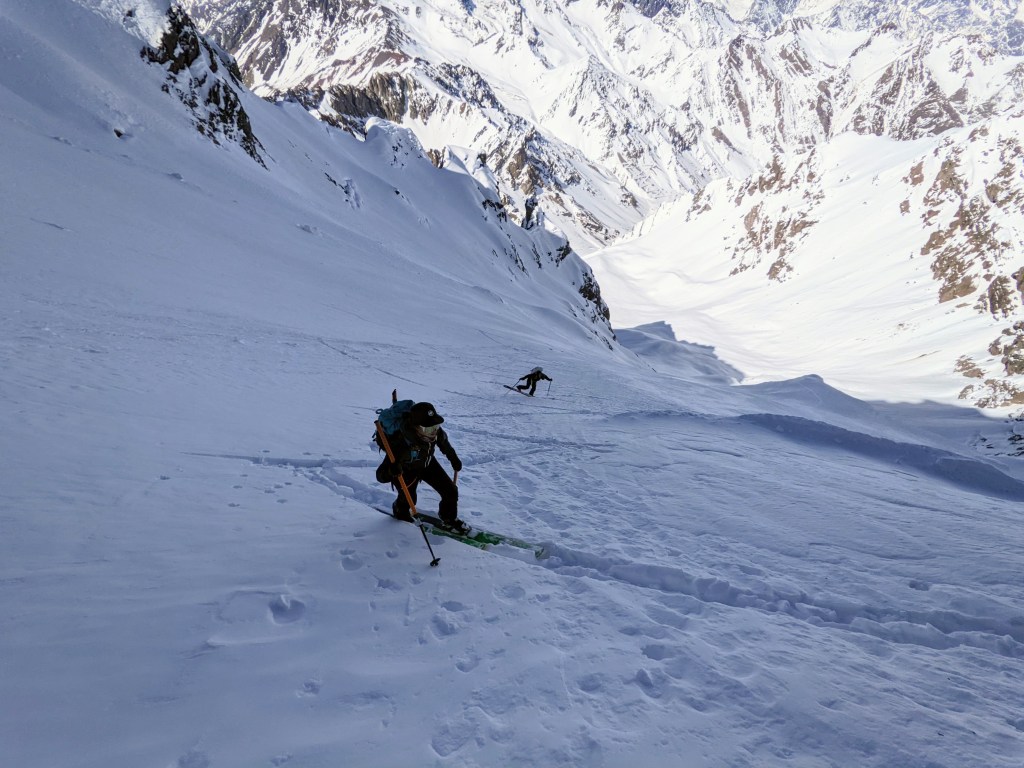
Curtis and Keane climbing the ridge near 8,500’.
We slept in expecting the bad weather to continue, but at noon it started clearing up. We decided to pack up and make a push. The first thousand feet of the climb brought us to the false summit at 9,900’ and the first exposed section.
Following in Curtis and Keane’s footsteps, Ben and I avoided a couple holes Curtis had found. The top of the false summit narrowed and felt a bit like a tight rope walk. From there we had 400’ to descend. As I plunge stepped down, I suddenly felt the ground beneath my leg give way. I looked back at my leg to find it disappearing into a bottomless crevasse.
After extricating myself from the hole, Ben and I continued to the col where Curtis and Keane were eating lunch. It was 5 pm. We briefly discussed our options and decided to continue. The next section would be the toughest climbing yet. As Keane and Curtis set off, Ben and I took in the sight: a knife-edge ridge with thousands of feet of exposure and massive hanging glaciers on either side.
Curtis and Keane eating lunch before the most exposed part of the ridge, 9,500’.
We started climbing, the last of us collecting the pickets loosely placed for protection. The going was slow, the cornices huge, and the drops long. By 10 pm we made it to 11,000’ and decided to call it a night.
The only problem was any flat area was extremely exposed to storms. We decided to chop a tent platform into the west side of the ridge, but the snow was more like ice at this elevation. We spent 2 hours chopping away to get a tiny tent platform. The back of our platform was bordered by a crevasse of unknown size. After a carefully choreographed dance to pitch the tents, we crawled in and got to sleep by 1 am.
The next day was cloudy and snowy. Curtis and I dug another snow cave, not wanting a repeat of the first night. The going was slow as we chopped out ice chunk after ice chunk. Eventually we finished, despite breaking a shovel, and created a cozy home for the next few days. Weather looked good for the following day, so we planned a summit push.
Keane leading up the ridge past huge cornices, 10,000’.
At 3:30 am the weather looked great. A gorgeous sunrise illuminated our tiny perch and the rest of the range. We were off by 5 am.
Ben and Keane’s tent perched on our tent platform on summit attempt morning.
From camp, the biggest obstacle visible was a huge glacial ice wall blocking the entire ridge. Within 30 minutes, we arrived at its base. Unsure of what to expect on the route, we had brought a handful of ice screws and technical tools. Going straight up and over would be crazy with our amount of gear. Ben and I explored a route off to the right, but the wall just kept going. We ended up going left, climbing 30’ of glacier ice, then nearly a rope length of snice (halfway between snow and ice) that barely took pickets. It took 2 hours to climb 200’.
Mt Balchen (11,140’) and Mt Geist (10,720’) illuminated by the sunrise on summit attempt morning. Mt Hess (11,940’) and Mt Deborah (12,339’) can be seen in the background.
As we continued up a snow slope above the wall, the winds began to pick up. Keane and Curtis waited for us at 12,000’, and by then the winds were ripping. We made a quick decision to bail based on the winds and the potential for wind loading of slopes.
As we descended into the quickly growing winds, I looked back to see a lenticular cloud engulf the summit and extend miles to the west. It was about to get nasty. At the top of the ice wall, the winds were a sustained 60 mph. Having no good snow to build an anchor in, we placed a few pickets and screws for mental protection and downclimbed. Eventually we used one solid picket to lower off. We returned to camp and were in a blizzard an hour later. We hunkered in the cave, shoveling the entrance every 20 minutes so we weren’t snowed in.
Keane leading the first section of the ice wall as the clouds start to move in. We would later retreat this same way under gale force winds.
In the morning, we decided to descend off the mountain. Fearful of what could have happened if we were on the summit ridge when the storm rolled in and an approaching time crunch, it was an easy decision to make. We packed up and started down. Reversing the knife-edge ridge seemed easier than coming up; the snow on the west side was perfect for front pointing and super fun.
At 8,500’ we descended into the clouds. With so little ridge left, we kept going until we found the skis that marked our ascent path. Keane and I plunge stepped our way down, leaving Curtis and Ben to get some turns. In the flat light and punchy snow, they decided to walk down, much to the amusement of me and Keane.
We descend from our high camp to the glacier camp in one day of nice weather.
Day 7 was the hardest day of the whole trip. Keane and I started down the glacier on snowshoes. Eventually Ben and Curtis would join us on snowshoes once again due to a snow crust. We travelled the 4 miles to the airstrip quickly and unburied our gear. It survived the squirrels!
After a relaxing lunch on tundra, we loaded up our packs and began the 10-mile trek to our put-in on the Little Delta River. With 70+ lb packs, we knew this wouldn’t be fun…but we had no idea. The farther we went, the softer the snow got. Keane and I stopped halfway across the Hayes Glacier for a bouldering break. We got some fun first and likely last ascents in our climbing boots.
Hours later, as we approached the terminus of the glacier, we started to posthole. Our snowshoes made no difference, and every other step we sank to our hips. We struggled for 7 miles, until we descended to Hayes Creek hoping it would be floatable. It was not. We continued our struggle. Eventually we made it to where the snow thinned and we could walk on tundra, but now we had a mile of tussocks to deal with. We met up with Ben and Curtis, who had only a slightly better experience, pitched camp at the river on a sand bar and built a fire. Solid ground was glorious.
Our first camp on solid ground! It signified the trip was getting close to its finish….but we weren’t done yet!
The next morning was slow. We got up, built a fire, relaxed, and drank coffee. Eventually we decided we should get moving, so we hiked the last ¼ mile to the river and inflated our packrafts. We pushed off at 2:30 pm.
The second to last time hoisting these packs on to our shoulders for ¼ mile walk to the river. The last time would be hiking a mile from the river to the road.
The first few miles of the float were a fun, splashy, class II river. It was shallow and involved a lot of butt scooting. A handful of small rapids were a blast to run. As the river got larger, the overflow started. Throughout the winter, sections of the river overflowed and froze. Now, these sections were 2’-6’ thick with ice. The river entrenched itself or was diverted. The risk increased dramatically. There was always the possibility to round a corner and find an ice jam, ice bridge, or the river diverting through brush. With the entrenching of the river, there were limited spots to bail if a hazard was encountered, as the ice walls rose to 6’ high on either side.
We are all excited and nervous for what the river portion of the trip would have in store for us. Luckily nothing went wrong.
In one location, the river flowed through a section of alders, so we got out and dragged our boats on top of the ice for a half mile. In another location, the river flowed under the ice, so we dragged again. In some places, the river divided into many shallow channels: more dragging. By mile 23 it was getting late, so we pulled over to look for a camp site. While approaching our sand bar, an ice shelf collapsed near Ben, and he surfed the wave downriver. An exciting end to the day.
One of the many seemingly endless sections of overflow ice. Whatever happened, we were trapped and committed to the float.
Our final day started earlier; we were floating by 8:30 am. We encountered more ice jams and more boat dragging. Then river diverted through the forest, so we dragged. Finally, the river opened again, and we could once again float. We floated through one more overflow section; this one was by far the worst. The walls towered 8’ over us, and the channel narrowed. While Keane and I waited for Ben and Curtis to run the next corner and give us the all-clear, a massive ice ledge collapsed and nearly washed us away.
As we continued, the overflow gave way to logs. Summer runoff had not pushed the winter’s carnage downstream yet, so we navigated around huge piles of logs and uprooted trees. The river picked up speed. By 1 pm, we arrived at the Tanana River and had the only 2 relaxing miles of the whole float. The entirety of the Little Delta was mentally exhausting, constantly being prepared for whatever lay around the corner.
Once we reached the take-out, a short hike brought us to the highway and our shuttle vehicle. Upon reaching town, temperatures soared above 70°F and the trees were in full on bloom. What a dramatic change from 2 days earlier and 11,000’ higher.
Finally at our shuttle location! We were all happy with how the trip turned out even if we did not make it to the summit.
We are all still amazed at the adventure we were able to pull off, and incredibly grateful for the support of CalTopo and the Alaska Alpine Club. This adventure would not have been possible if not for that support. Although we did not summit, we all returned safely, and I’m sure we’ll be back to Mt Hayes again in the future.
Sean and his team used Sentinel Weekly satellite imagery to keep an eye on recent conditions (such as overflow sections on the river) prior to their trip. Sentinel Weekly and other powerful planning tools are available to pro or desktop subscribers. Visit our Individual Accounts page to learn more about the features and pricing of all of CalTopo’s individual subscriptions.
https://i0.wp.com/blog.caltopo.com/wp-content/uploads/2022/09/tent-on-mt-hayes.png?fit=2240%2C1260&ssl=112602240Meghanhttps://blog.caltopo.com/wp-content/uploads/2019/10/caltopoLogo_menu1.pngMeghan2022-09-01 11:54:312023-02-16 12:46:16Climbing Mt Hayes & Packrafting the Little Delta River
Rain Felkl is a 2022 CalTopo Adventure Grant recipient. Along with three partners, she attempted to ski traverse the Lyngen Alps in Norway in late April. They also identified possible side trips for additional ski descents along the way. Below is her trip report- enjoy!
Our team of 4 – Clay James, Lisa LaCampange, Freddy Mondale and myself set out to complete the Lyngen Alps Traverse and with research beforehand we mapped out multiple ski objectives along the route.
Freddy and Lisa had recently moved to Zurich, Switzerland so it was helpful to use a shared CalTopo map for all four of us to add potential routes, ski lines and campsites as we read through the guide books. By using a shared CalTopo map, everyone could view the map and newly added objectives on their own schedule. To learn more about how to share and collaborate on the same map with your partners, check out the Map Sharing page in the CalTopo user guide.
Although we planned to tent camp for the entire route we mapped out the location of huts as shown in the map below. These are first come, first serve backcountry huts throughout the alps. They were much lower in elevation than our planned traverse route, however, a good escape option if weather were to come in. These huts came in handy and I was happy we took the time to map their locations beforehand.
CalTopo map showing the Lyngen Alps Travese (Scanned Topos and Slope Angle Shading layers)
We were going to complete the traverse in two legs taking about a week each with the ski objectives, the south side first and the north side second. In between the legs we would take a restock and rest day in the town of Lyngseidet.
Once we arrived in Tromso the weather forecast was looking grim. The 10 day forecast consisted of mostly new snow and wind. We opted to give it a shot anyway knowing there are a handful of drainages to exit along the route.
Bus stop to the start of the traverse. Photo by Rain Felkl.
Once we hit the high alpine on the first day it was white out and we continued forward navigating through until our first camp. That night it snowed a foot and winds were higher than forecasted. We checked the weather religiously that morning with no hope in sight for the foreseeable 10 days and the storm worsened for the next 4 days. We decided to swap our heavy packs and dehydrated meals for lower elevation tree skiing from the multiple backcountry ski huts within the Alps.
Low vis on day one. Photo by Rain Felkl.
Once we exited we caught the bus and made our way to the Magic Mountain Lodge in Lyngseidet. Freddy had stayed there a couple years back and knew it was an incredible location and place to stay for ski access complete with the friendly owners Patrik and Henrika. From here, we calculated our next moves. Regardless, we were going to be riders of the storm.
Next moves. Photo by Rain Felkl.
We decided on a ski hut with great access to trees for visibility, Kvalvikhytta. We made the hut home for the next four days surfing all the fresh powder! Our entire stay no one else came to stay in the hut, although we had two parties come in to warm up after a day trip up the drainage to ski. The hut caretaker told us to make it to the high pole he pointed out on a map and that the ski down from there was some of his favorite terrain during a storm, so naturally we made it to the pole. Great riding!
Fred and Lisa at the pole. Photo by Clay James.
After our stay at Kvalvikhytta, we traversed under Kavringtinden peak and Goalservarri peak back to Lyngseidet for a restock on food. That evening we caught the bus to our next drainage, staying at the Steindalhytta. The terrain around Steindalhytta had trees, beautiful large avalanche paths and access to Steindalsbreen glacier which led to large alpine peaks like Imagáisi and Nállangáisi. It seemed as though there could be a break in weather within the next couple of days so we wanted to set ourselves up in a position to access larger peaks if the weather did break.
As the storm continued we rode the glorious avalanche paths lined with trees and blanked in fresh new powder. One morning the weather was clear and we were ready. We rode a remarkable south facing couloir, then headed out to the glacier to potentially ride the NE face of Imagáisi. As we wandered up the glacier the clouds began to roll in once again, visibility rapidly decreased and the snow and wind began again. We descended the glacier back to the hut without riding Imagáisi. It was glorious to get up higher and finally get a view of potential terrain.
Lisa staring into the south facing couloir. Photo by Clay James.
After a couple days exploring the terrain around Steindalhytta, we exited to catch the bus back to our base in Lyngseidet at the Magic Mountain Lodge. From there we explored more terrain around various backcountry huts cross referencing CalTopo maps and Lyngen guide books for our next zone. With only a few days left in our trip and the weather windows being at very odd times of the night, we figured the best option would be to be flexible and stay in Lyngseidet and rent a vehicle instead of relying on the bus schedule.
With the snow continuing to fall we heard of a unique tree skiing zone in Tamok so we decided to take the bus/ferry to Tromso, rent a car and stop in Tamok to ride on our way back to Lyngseidet. Once we arrived, we realized the Øksehøgget Couloir was in the area. We decided to go give it a look and potentially ride it bottom up. No dice on the couloir as the wind picked up rapidly. It was a beautiful feature to come back to in the future.
Øksehøgget Couloir. Photo by Rain Felkl.
Finally the late night weather window we had been waiting for appeared in the forecast and we were ready! We decided on Ellendaltinden’s inspiring west couloir. Since the sun wasn’t setting in Northern Norway at this time we really didn’t have a time limit and began walking at 3PM. The snow was pristine and deep. Lucky for us Patrick let us borrow his homemade verts before we left that evening. They were made with shovel blades and vollie straps, these saved our energy and worked fantastic. We swapped leads setting the 700 meter boot pack. We stopped just shy of the summit due to a hard wind slab formation. I had the best conditions and ride of the season surfing down Ellendaltinden.
Ellendaltinden west couloir. Photo by Freddy Mondale.
The boot pack. Photo by Freddy Mondale.
It was 2am when we arrived back at the magic mountain lodge, Freddy and Lisa went out for another ski around Goalsevarri while Clay and I went to rest. Our final day was clear but temps were high and there was no refreeze overnight, we tip-toed checking out a final zone out of Koppangen and didn’t get too far until the heat became overbearing.
The following day we left back to Tromso to collect our excess luggage we left at a hotel and spend the final night repacking before the flight. We hit the town and met some locals who had nothing but great things to say about Northern Norway and the access to inspiring terrain looking over the endless fjords. We are thrilled to make our way back to this land and give the traverse another shot when weather allows.
Lisa and Clay hyped. Photo by Rain Felkl.
Rain and her team used CalTopo’s international base layers to plan their ski traverse and objectives. CalTopo offers worldwide coverage for the MapBuilder Topo, MapBuilder Hybrid and Global Imagery base layers as well as more limited international coverage for Scanned Topos. These layers can be downloaded for offline use on your mobile device with a mobile, pro or desktop subscription. Visit our Individual Accounts page to learn more about the features and pricing of CalTopo’s individual subscriptions.
https://i0.wp.com/blog.caltopo.com/wp-content/uploads/2022/07/Clay-James-@cj_surmounts-9.jpg?fit=6000%2C3376&ssl=133766000Meghanhttps://blog.caltopo.com/wp-content/uploads/2019/10/caltopoLogo_menu1.pngMeghan2022-07-13 09:31:192022-07-13 15:38:39Ski Traverse of the Lyngen Alps in Norway: Low Vis, High Adventure
Top row (left to right): Sean Marble, Niki Choo Bottom row (left to right): Jessica Johnson, Aidan Goldie-Ahumada, Rain Felkl, Miles Knotek
We were blown away by the creativity, passion and love for adventure and exploration conveyed by everyone who applied for the CalTopo Adventure Grant. After carefully reviewing all applications, we are proud to announce the 2022 CalTopo Adventure Grant recipients:
Sean Marble: climb the North Ridge of Mt Hayes (13,832′) and packraft out the Little Delta River in Alaska
Niki Choo: connect Pacific Ocean to Arctic Ocean in Canada/Alaska by canoe and ski
Jessica Johnson: non-binary solo unsupported fastest known time (FKT) attempt on Toiyabe Crest National Recreation Trail, Nevada
Aidan Goldie-Ahumada: climb and ski Pomerape (20,610 ft) and Parinacota (20,932 ft) in the Atacama Desert, Chile
Rain Felkl: ski traverse of the Lyngen Alps in Norway combined with multiple ski objectives along the route
Miles Knotek: traverse of Montague Island, Alaska
Each recipient will receive a financial award for their trip, a 1-year pro account and the opportunity to attend a virtual training on how to get the most out of the app. After completing their trip, each participant will produce a written trip report with photos and/or videos that we will share on our blog and social media.
We hope you are as excited as we are to check out their trip reports and follow along on their adventures!
https://blog.caltopo.com/wp-content/uploads/2019/10/caltopoLogo_menu1.png00Meghanhttps://blog.caltopo.com/wp-content/uploads/2019/10/caltopoLogo_menu1.pngMeghan2022-04-19 09:03:262022-04-20 05:17:04Meet the 2022 CalTopo Adventure Grant recipients!
THE 2022 ADVENTURE GRANT IS CLOSED. Looking for the 2023 Adventure Grant? You can apply here.
Whether it begins with a spot on a map that piques your curiosity or a photograph that you can’t get off your mind, exploration is all about pursuing what inspires you. Through our interactions with users, we’ve seen that you all use CalTopo for some pretty imaginative and memorable endeavors and we’d like to help support your next adventure.
We are excited to offer a number of small grants to motivated individuals and teams undertaking unique and personally challenging outdoor adventures. These grants are aimed at trips involving creative objectives, significant trip planning, and at least some off-trail travel.
About the Grant
The CalTopo Adventure Grant aims to support trips with an emphasis on adventure and exploration rather than technical difficulty (although technical objectives are still encouraged) . Multiple grants totaling up to $5,000 will be awarded to individuals or teams with trip proposals that best meet the grant criteria.
Grants vary by project and can be used to help cover travel, gear, and other expenses related to the trip. Grant recipients will also receive a 1-year CalTopo pro account plus a virtual training on how to get the most out of the CalTopo platform with the CalTopo training team.
Application Period
The grant application period opens on February 1, 2022 and runs until March 11, 2022. Applications must be submitted via the online application no later than 11:59 p.m. MST on March 11th.
Grant recipients will be announced in March after the selection committee has reviewed all applications and made their final decisions.
Criteria & Guidelines
Trip proposals will be considered based on exploratory and adventurous nature, complexity of trip planning required, and uniqueness and creativity of the objective. Trips may last one or multiple days. Types of travel may include but are not limited to: backpacking, hiking, mountaineering, long distance trail running, AT skiing/splitboarding, biking, canoeing/kayaking/rafting or alpine climbing. Trip proposals that incorporate more than one mode of travel (such as road biking to a traverse of multiple peaks) are encouraged. Commercial or guided trips are ineligible.
All trips must be conducted in an environmentally conscious manner, with care and respect for local communities and wildlife. All trips must be legal and obtain all necessary permits required by local authorities.
Trip must be completed by March 31, 2023.
Grant applicant and their partners must be at least 18 years of age and complete all liability releases. The applicant and their partners’ overall outdoor experience level must match the proposed objective. Trip proposals can involve amateur or professional athletes who are supported either financially or in-kind, but the support level must be disclosed.
Recipient Responsibilities
Recipients should do their best to practice environmentally low impact and leave no trace ethics, acting as strong mountain stewards.
Within two months of completing the trip, recipients are expected to produce a written trip report that includes photos and video for posting on CalTopo’s website and social media. Written reports will ideally be at least 1,000 words in length and summarize the trip from start to finish, including but not limited to: what inspired you to pursue this objective in the first place, trip planning involved (including logistics, route planning and your CalTopo map), a description of the trip itself, and any lessons learned that could help future parties. Documentation should also highlight how CalTopo was used throughout the trip, including during the trip planning process and in the field. A virtual training on how to get the most out of the CalTopo platform will be provided to all participants prior to their trip.
Recipients are encouraged to make their trip report come alive with photos, videos and drawings. The more informative, reflective and creative your trip report, the more widely we will be able to share it on CalTopo’s website and social media.
Additional information
If your trip is cancelled, rescheduled after March 31, 2023, or significantly altered in some way, all funds must be returned to CalTopo. Please contact the grant manager at info@caltopo.com if your proposal changes.
Grant money will only be released once the recipient has obtained all necessary permits and/or visas.
Any photos of the team or individuals submitted with a trip report may be reproduced in any manner that CalTopo desires. CalTopo will have the right to use photos and video submitted with an expedition report on the CalTopo website or marketing materials.
Any questions regarding this grant should be directed to the grants manager at info@caltopo.com.
THE 2022 ADVENTURE GRANT IS CLOSED. Looking for the 2023 Adventure Grant? You can apply here.
https://blog.caltopo.com/wp-content/uploads/2019/10/caltopoLogo_menu1.png00Meghanhttps://blog.caltopo.com/wp-content/uploads/2019/10/caltopoLogo_menu1.pngMeghan2022-02-01 09:51:092023-03-03 13:48:28CalTopo Adventure Grant is open!